Scroll To Top

Mamshit (Mampsis) National Park

Click the title to view map

Journal Entry

In addition to documenting archaeological sites, I occasionally include journal entries from my travels in the Holy Land. These experiences often reveal aspects of the land and its people that photographs of ancient ruins cannot capture.


Site Overview

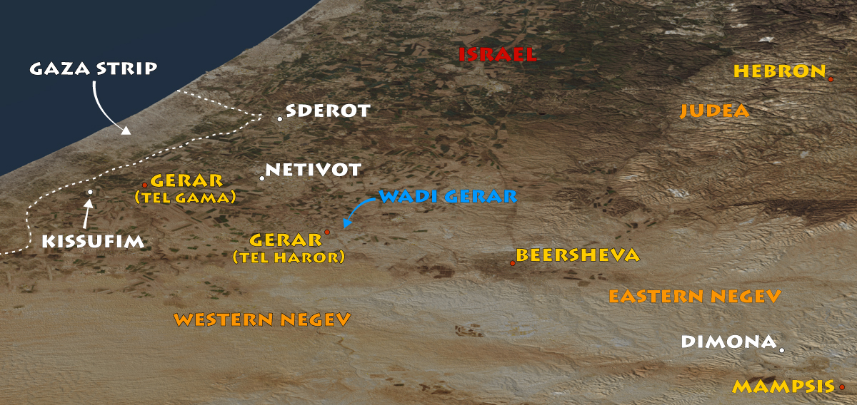
  • Region: Eastern Negev
  • Biblical Territory: Judah
  • Modern Site: Mamshit National Park

Mamshit (ancient Mampsis) offers a remarkable glimpse into how the Nabateans transformed the harsh Negev Desert into a thriving center of commerce. Situated along the Incense Road, the city prospered through long-distance trade between Arabia and the Mediterranean world. Today, visitors can walk its ancient streets, explore the remains of wealthy residences, admire Byzantine churches and mosaics, and examine the sophisticated water systems that sustained life in one of the driest regions of the Holy Land. Few archaeological sites illustrate the resourcefulness, wealth, and adaptability of the Nabateans as clearly as Mamshit.

As visitors explore Mamshit’s water systems, they are reminded that the challenge of making the desert bloom did not begin in modern times. The ingenuity displayed here by the Nabateans echoes the determination and innovation that continue to characterize life in the Negev today.


History of Mamshit

The Nabateans were an ancient Arab people whose capital city was Petra in present-day Jordan. Located 3.9 miles (6.25 kilometers) east of Dimona in Israel’s eastern Negev, Mamshit was an important stop along the Incense Road that connected southern Arabia with the Mediterranean world. Caravans transported valuable commodities such as frankincense and myrrh through the region, bringing wealth and prosperity to the settlement.

Although the site originated during the Nabatean period, most of the structures visible today date to the second century AD, after Rome annexed the Nabatean kingdom in AD 106. The city’s large residences, public buildings, and sophisticated water systems reflect a thriving community that successfully adapted to life in one of the harshest environments of the ancient Near East.

The dams on Wadi Mamshit testify to the Nabateans’ remarkable ability to collect and store scarce rainfall. By channeling seasonal floodwaters into reservoirs and cisterns, they transformed a barren desert landscape into a prosperous settlement (see the fifth photo below).

During the late Second Temple period (c. 63 BC–AD 70), the Nabataeans controlled much of the desert trade passing through the Negev. Their kingdom frequently interacted—and sometimes clashed—with the neighboring Herodian dynasty, whose founder, Herod the Great, was descended from the Idumeans, the descendants of the ancient Edomites. The ruins of Mamshit preserve a remarkable window into this often-overlooked world that existed alongside the events of the New Testament.

Mamshit - The Western Chapel

View east: The eastern church of Mamshit, known as the Church of the Martyrs, contained reliquary chests holding the remains of saints and martyrs in rooms flanking the apse. These sacred relics connected local worshippers with the heroic and often persecuted generations of early Christianity.


Mamshit (Mampsis)
Mamshit (Mampsis
Mamshit (Mampsis
Mamshit (Mampsis
Mamshit (Mampsis
Mamshit (Mampsis
Mamshit (Mampsis
Mamshit (Mampsis
Mamshit (Mampsis
Mamshit (Mampsis
Mamshit (Mampsis
Mamshit (Mampsis
Mamshit (Mampsis
Mamshit (Mampsis
Mamshit (Mampsis

Mampsis - The Western Chapel

Mamshit (Mampsis)

The entrance to Mamshit National Park.

Mamshit (Mampsis

Fun facts about the Nabateans, posted on a sign as you enter the park.

Mamshit (Mampsis

The desert area crossed on the hike from Dimona to Mamshit, visible between the two hills (top right).

Mamshit (Mampsis

Dimona is visible in the distance (top center). View of the eastern Negev from the lookout tower at Mamshit.

Mamshit (Mampsis

The city gate consists of two towers and a central passage. When it was built during the late Roman period (third century AD), Mamshit was surrounded by a wall approximately 3,000 feet (900 meters) long. The gate appears on the sixth-century AD Madaba Map mosaic, attesting to the city’s importance.

Mamshit (Mampsis

One of three ancient dams on Wadi Mamshit, built to control the water from flash floods in the Negev.

Mamshit (Mampsis

The continuation of Wadi Mamshit along the southern side of the Nabatean city.

Mamshit (Mampsis

An artist’s depiction of the flour mill (next photo) at Mamshit.

Mamshit (Mampsis

The remains of a flour mill as seen from the lookout tower. Two complete upper millstones and several millstone fragments are visible (see the millstone depiction in the previous photo). The millstone bases are missing.

Mamshit (Mampsis

The reception hall of the “Nabatu house” with columns that once supported a second floor. It was the largest house in the city, with an area of 21,500 square feet (2,000 square meters).

Mamshit (Mampsis

Arches that supported the second story of the “Nabatu house.”

Mamshit (Mampsis

This Byzantine bathhouse contained three rooms: a hot room, a tepid room (pictured here), and a combined dressing and furnace room.

Mamshit (Mampsis

The north side of the grand stable (see artist’s depiction in the next photo), evidence of the owner’s wealth.

Mamshit (Mampsis

Depiction of the grand stable in the “Nabatu house,” so named because of its many Nabatean features. The remains of the stable are pictured before and after this photo.

Mamshit (Mampsis

The south side of the grand stable (see artist’s depiction in the previous photo).

Top

Journal Entry (August 4, 2025)

Hike to Mamshit National Park

Yesterday I went to the Nabataean site of Mampsis in Israel’s Negev desert. Since the bus driver to Eilat wouldn’t let me board without paying the full price to Eilat (I was getting off at Dimona), I took the train to Beersheba and then a bus to Dimona. From there, I hiked across the desert to Mampsis (3.9 miles/6.25 kilometers). Last time I posted, I wrote a little bit about why I hike. Today, I hiked to experience the land of Abraham, Isaac, and Jacob. However, something unanticipated occurred, which is not uncommon, and another reason for hiking. It’s when I get to interact up close with local folks. I came across a crew of men welding large pipes together.

I’m not sure what the pipes are for, but I assume they are for water. Walking along, I heard a shout. Three men got together, arms around shoulders, and motioned for me to take their picture. They must have seen me take photos of their operation. Well, I was about thirty yards away, so I ran down the hill to get a closer view. You can see the photos below. After I took a picture of the first group of men, another group, a little way away, got together and asked for a picture. After the photo op, they all ran up with questions. What stood out then and now is how happy they were. They wanted to know where I was from, what I was doing, and so on. Did I need anything? Cold water? Coffee? We had a good time, and I made some new friends. As I turned to leave, their leader (the smaller man wearing a green sweatshirt) brought me a coffee. I thanked him profusely and pretended to drink it as I walked away.

If I hadn’t been hiking, I would have missed the entire experience. On my way back from Mamshit, I stopped again and spoke with the foreman. He asked whether I was Jewish. I told him I was not, but that I was a Christian. He broke into a broad smile, extended a rough hand, and said, “So am I.” It turns out he’s from a town close to Nazareth, between Nazareth and Haifa. Mampsis was great. But this experience made the whole effort worth it. I sent copies of the photos (minus the coffee cup) to the tall man who gave me his email address. He said he’d distribute them among the group.

Click the map to toggle between the labeled map and the satellite image

Satellite Map - Mamshit

View north: Sderot and Netivot lie north of Gerar in the western Negev. Both cities were among the communities affected during the Hamas attacks of Oct. 7, 2023. Their inclusion on the map helps orient Gerar within the modern landscape of southern Israel. I visited Gerar two days after hiking to Mamshit, drawn by its biblical associations with Abraham and Isaac.